Air Quality around West Jesmond Primary School – Autumn 2018
The area around West Jesmond Primary School is very busy with traffic from the three schools on Tankerville terrace, which SPACEforJesmond believe should be a priority for our community to address. High levels of traffic around the schools – some from within Jesmond and as little as 300 metres away – create an unsafe and polluted environment for our children.
In order to quantify pollution levels, last winter SPACEforJesmond used a portable air quality monitor to sample the air around Jesmond, primarily on the school run and around West Jesmond Primary school. This revealed “hotspots” of pollution in areas where it might be expected, such as Osborne Road and Tankerville Terrace. The portable air quality monitor measured particulate matter (PM) of various sizes, all of which have a detrimental effect on our health. The monitor did not however measure Nitrogen Dioxide (NO2) which is the focus of much attention at the moment due its harmful effects, especially on children, who are still developing physically. NO2, a bi-product of diesel combustion, has an impact on respiratory health and development and has been indicated as a cause of obesity in children.
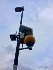
The air quality monitor is mounted on a lamp-post and solar powered
Thanks to the Urban Observatory, a lamp-post mounted air quality monitor was installed outside West Jesmond Primary School for the start of the new school year. This sensor measures, amongst other things, Nitrogen Dioxide (not to be confused with Nitrous Oxide, a.k.a. laughing gas).
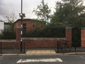
Urban Observatory air pollution monitor outside West Jesmond Primary School, Jesmond
Results
The results from the first school term highlight the impact of the morning school run. The peak value on a weekday occurs between 8am-9am, when the level of pollution doubles (44ug/m3) compared to the background levels in the middle of the night. The levels rise less dramatically for the afternoon run, presumably due to the mix of after-school clubs and different approaches to picking children up at the end of the day.
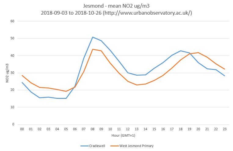
West Jesmond Primary Hourly mean, NO2 ug/m3, weekdays only during the first half of the 2018 autumn term
What’s really interesting to note is that, on weekdays, the area around West Jesmond Primary is almost as polluted as the A1058 Coast Road. The daily mean value for the Coast Road NO2 during this period was 31.5ug/m3 (measured at the Cradlewell Urban Observatory high precision air monitor). The value for the sensor at WJPS was 30.2ug/m3.
So, what does this mean? It’s important to note that there is nothing illegal about these levels of pollution – the monitor outside WJPS is not a legally designated site, and the annual mean limit set by the EU is 40ug/m3. After a year’s worth of monitoring, it will be possible to compare these levels against the legal limits.
Despite this, the data indicates that the morning rush around Tankerville Terrace effectively doubles the pollution levels and that for the first school term, weekday pollution here was similar to the A1058 at Cradlewell, which is the location of a DEFRA network station, the measurements of which are close to breaking the legal annual limit on NO2, and have done in previous years.
Diesel combustion is also temperature sensitive and many of the pollution removing features are turned off in cold weather and this is true whether the vehicle is moving or idling. It is common to see people idling for periods of time outside the school – likely to keep the heater working – and this produces pollution too. A colder spell could really increase pollution in the area and SPACEforJesmond will continue to monitor this site.
Our view
In our view it’s vital that councillors and council officers take action to protect children on the school run by reducing polluting traffic and enabling walking and cycling to school. Children who are driven, some from very close by, are receiving a double-dose of negative health impacts through inactivity and exposure to pollutants. This is being already addressed in schemes elsewhere in the UK – such as Hackney School Streets and Edinburgh School Streets – and Newcastle should follow their lead, as a UNICEF child friendly city, to do what is right for children in Jesmond.
